OPINION: ‘Map of the History of Thailand’s Boundary’ Misleads Thais from Childhood
AKP Phnom Penh, December 22, 2025 --
What exactly are Thai children taught about Cambodia and other neighbouring countries when they go to school?
According to the 1994 book “Siam Mapped” by Thai historian Thongchai Winichakul, much can be traced to an influential map distributed during World War II, when Vichy France-administered Indochina ceded parts of Cambodia and Laos to Thailand.
According to Thongchai, the “Map of the History of Thailand’s Boundary” assumes the existence of a “total legitimate realm” of the country.
A MAP DIVORCED FROM REALITY
“It is not clear, however, where this legitimate realm came from,” he writes. “The map is in no way a scientific record of any geographic reality.”
Thongchai notes that there were “many versions of the map”, with at least one dating back to 1935. One map adds Singapore and the present-day southern Malaysia states of Johor and Malacca, while some include the Shan states in northeast Myanmar and Xishuangbanna in China’s Yunnan province.
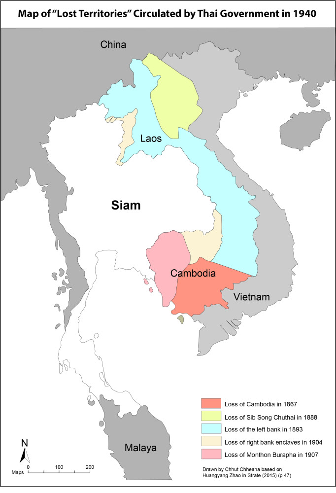
In the popular one reproduced from the original in Thonchai’s book, eight territorial “losses” going back to the late 19th century are marked by the numbers 1 to 8.
The first and second — present-day Penang in Malaysia from 1786 to 1800 and present-day Tanintharyi Region in southeast Myanmar in 1793 — are sometimes omitted from some versions “as they took place in different contexts,” Thongchai says.
Numbers three to seven focus on French Indochina — most of Cambodia in 1867, parts of northwest Vietnam in 1888, the left bank of the Mekong (most of present-day Laos) in 1893, enclaves on the right bank of the Mekong facing the Lao provinces of Luang Prabang and Champasak in 1904 and the Cambodian provinces of Siem Reap, Battambang and Sisophon in 1907.
The eighth perceived loss (to the British, in this case) is the Malaysian states of Kedah, Perlis, Kelantan and Terengganu in 1909.
‘DISTRIBUTED TO SCHOOLS’
“In 1940, this map was distributed to schools and government offices throughout the country,” Thongchai writes.
The British consul considered the map as a gesture of Siamese “imperialism” and joined with the French charge d’affaires in making a protest.
Thailand’s Ministry of Defence “explained it away, saying that it was used exclusively for historical study.”
But the map was later used by a movement calling for the return of territory from French Indochina.
Amid British alarm that the movement would also seek its Malaysian territories, Prime Minister Plaek Phibunsongkhram “gave his word to the consul that such would not be the case, and he would stop the distribution of the map,” Thongchai says.
But an advisor to Phibun — who modeled himself on the Italian fascist wartime leader Benito Mussolini — “had it published again and sold it at the price of one-tenth of a baht per copy.
“Again the government, denied any involvement in its publication and ordered its sale to be stopped.”
But the legacy of the map remained.
“Even now, the map is easily found in school textbooks and most Thai atlases,” Thongchai says.
‘A SENTIMENTAL VISUAL CODE OF HISTORY’
“The map has lost its immediate political thrust. But its function as a sentimental visual code of history persists.
“Its power over the discourse of the nation’s biography has not been diminished.”
A similar map is reproduced in “The Lost Territories” by American historian Shane Strate.
Published in 2015, Strate’s book contains a map that omits lands in Malaysia and Myanmar, focusing instead on the five Thai claims to “losses” in Cambodia, Laos and Vietnam between 1867 and 1907 — incidents three to seven from the eight shown in the map in Thongchai’s book.
According to the author, the focus on Indochina was deliberate, as Thai Prime Minister Phibun did not want to antagonise London by mentioning lands in British-administered Malaysia or Myanmar.
“At the height of Franco-Thai hostilities in 1940, when the Thai government was busily printing and distributing thousands of irredentist maps, Phibun sent explicit instructions to the Ministry of Interior to print maps displaying territorial concessions to France, but not other losses,” he writes.
A PERSISTENT STATE NARRATIVE
Strate concludes that Thai history mostly celebrates the “chosen myth” of perpetual independence from Western colonisation but sometimes rehashes the “chosen trauma” for political reasons.
“It is used by political groups to communicate a sense of the nation’s vulnerability. The message is one of unity: people are instructed to eliminate differences and unify behind the government’s agenda.
“If they fail to do so, the discourse warns, then the current generation may re-experience the partition endured by their ancestors.”
According to Thai journalist Pravit Rojanaphruk, “Thai students are taught a single version of national history where Thailand is the protagonist.”
‘EXTREME NATIONALISM’ IN SCHOOLS
Under such “extreme nationalism instilled in schools since childhood,” he wrote on Dec. 15.
Myanmar is seen as “the aggressor” even though Siam interfered in its internal affairs. Malaysian and Lao city-states are portrayed as “rebellious” requiring suppression — including by burning down Vientiane. Khmers are meanwhile seen as “cunning and untrustworthy,” Pravit says.
“Simply put, Siam was once a mini imperial power in the region, acting like a big shot in the neighbourhood who was then pressured by Britain and France, who snatched away territories that were loyal (or rather compelled to appear loyal) to Bangkok.”
According to Pravit, “the majority of Thais today genuinely believe that we are still the protagonist, the righteous party” — and that “Khmers are ‘cunning and untrustworthy’ as always.”
By Sao Da, an independent analyst
(The views expressed are his own.)